
Carl changing camera card.
For the past year and a half, several Headwaters Master Naturalists have been participating in the eMammal project. Conducted by the Smithsonian Institution’s Conservation Biology Institute (CBI) in Front Royal, the eMammal Project aims to produce the same kind of database of mammal movements and behavior that exists for birds, thanks to the efforts of millions of bird-watchers. Since you can’t very successfully go “mammal-watching,” something else has to be done. That something else is cameras.
Wildlife cameras with motion- and heat-sensors are placed at predetermined locations for three weeks at a time. Each time an animal is detected, the camera takes 10 pictures in 20 seconds; if the animal is still there, it takes another 10 pictures, and so on. The heat sensor is there to prevent the camera from photographing leaves swaying in the wind.
When the three weeks are up, the volunteer retrieves the cameras, switches out the memory cards and batteries, and moves the cameras to the next location. Each “location” is really three sites: one right on a trail, one 50 meters off the trail and the third 200 meters off the trail. The locations are determined by the lead investigators, who give us the GPS coordinates. Of course, they choose the locations by looking at maps, which do not show the vegetation—I often wished for a machete, especially trying to get to those 200-meter locations!

Carl locking camera in place.
Once the cameras are in their new positions, we take the now-full memory cards home, where a computer program supplied by the CBI analyzes the time-stamps on the pictures and organizes them into groups, each likely to represent a single contact. Our job is to examine each group, and try to decide what the animal is. Trust me, it’s not always easy…. (see below for an example.)
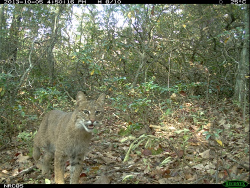
Bobcats are frequently “trapped” by eMammal cameras in our area.
For the first two rounds, in the Spring and Fall of 2013, each of us had 4 locations. Chip Brown’s and mine were on a Nature Conservancy-owned trail that begins on Route 39 at the Dan Ingalls Overlook on Warm Springs Mountain. Jerry Hopkins and Kate Guenther had locations on the continuation of that trail south of Rt. 39. In the Fall, Chip and I found ourselves in the area of Pitt Spring on Cub Run Rd. (on the eastern slope of Massanutten).
After the second round had ended, we were all invited to the Conservation Biology Institute in Front Royal for a “debriefing” and a tour of their captive-breeding operation. The data from the project are still being analyzed, and after a hiatus this Spring, the project will continue in the Fall, this time with the focus partially on more urban settings.
Between getting out into the woods every three weeks, and getting off-trail to boot, and looking at the sometimes thousands of pictures of everything from small birds to bobcats and bears, I personally found it to be a very enjoyable experience. – Carl Droms, HMN Cohort II
Check out the eMammal blogsite here and facebook page here.
Some images from the cameras prove challenging to identify what triggered them. Can you find the culprit in the photo below?
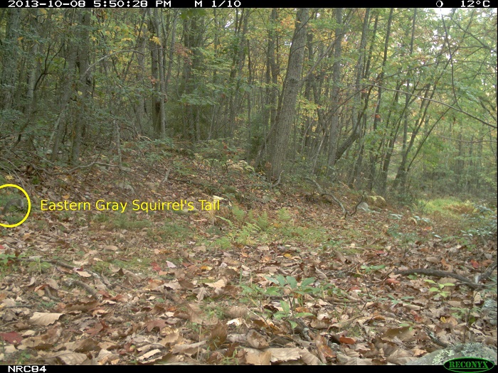
Click on the image to find the “culprit.”


